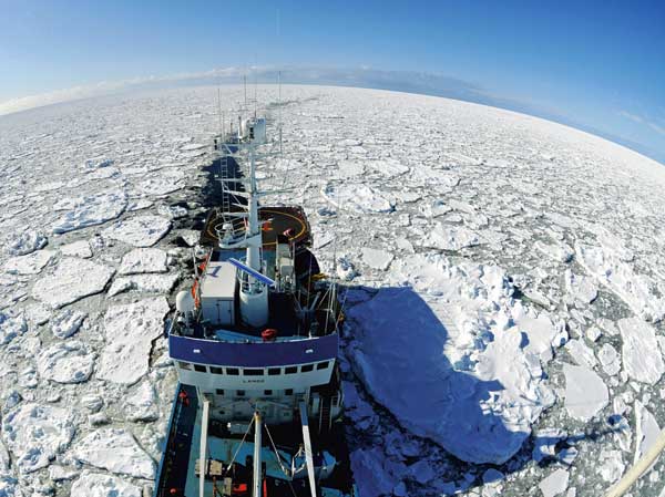
Polar perils
Activity in the Arctic is on the increase, but how safe is it to operate there?
KEY FACTS: At latitudes of more than 70 degrees north there are no good Internet systems. Satellite signals are difficult to obtain and other radio frequencies are very patchy.

INTERNET – NOT TO BE TAKEN FOR GRANTED
Beate Kvamstad is conducting research on radio signals and satellite systems at MARINTEK. She points out that the Internet is not available in areas without good coverage from satellites or land-based systems. The only exception is the oil and gas platforms, which have good Internet connections thanks to fibre optic cables from the coast.
Photo: MARINTEK
On a light June night in 1989 the Russian cruise ship Maxim Gorkiy glides peacefully along the coast of Svalbard. Suddenly there is a loud impact and alarm bells ring all over the ship. Just like Titanic, the ship carrying 973 German passengers has hit an iceberg. It takes on water and begins to sink immediately. Fortunately a rescue helicopter is stationed on Bjørnøya, and the Norwegian Coast Guard ship Senja is on patrol not far away. When Senja comes to the rescue three hours later, the cruise ship’s bow is already submerged to the level of the main deck. However, the coast guard crew manages to prevent Maxim Gorkiy from going down. The passengers, many of them dressed in nightclothes, are evacuated from the ice floes around the ship using helicopters, lifeboats and life rafts. They are then transported to Svalbard. Luckily, no lives are lost.
Increased activity
Russian cruise ships are not the only vessels sailing around Svalbard. Every year about 65 000 tourists come here, half of them on foreign cruise ships, and shipping activity off the coast is considerable.
The northern polar countries of Norway, Canada and Russia have begun to take a serious interest in the Arctic. One-quarter of the world’s oil and gas resources are thought to be found here, and the Norwegian authorities believe that the area will become Europe’s most important petroleum province. Many people believe that shipping will increase because of the melting of ice in the Arctic, resulting in a reorganization of global shipping routes. Others believe that navigating through the Northwest Passage will be too expensive and that traffic between America and Asia will continue as at present.
A study carried out by the CICERO Centre for Climate Research in Oslo, Det Norske Veritas and Statistics Norway concludes that there will be no major increase in oil and gas production in the region. However, they maintain that the melting ice cap will enable far more production offshore than at present, which in turn will result in a large increase in shipping activity. With activity throughout the area increasing, the risk of accidents will also increase.
Are you reading me? Over
A stone’s throw from the offices of the Norwegian Broadcasting Corporation at Tyholt in Trondheim, Beate Kvamstad is conducting research on radio signals and satellite systems. Her special area of interest is the range of the various communications systems in the northern-most parts of the planet. Now, like the state broadcaster in the neighbouring building, she wants to broadcast her message. This is, to put it simply: “It’s not good enough.” The clear findings of Kvamstad and her colleagues at MARINTEK (part of SINTEF) are that the communications systems in use in the northern regions are not in a healthy state.
“As we travel north of 70-75 degrees, we see that the satellite communications systems normally in use are very unstable,” she says. She points out that the Internet network that we take for granted almost wherever we are in the world is unavailable in areas that are not well served by satellites or land-based providers. The only exceptions are on oil and gas platforms that have good Internet connections thanks to fibre optic cables from the coast.

BARENTSWATCH
In May, a pilot project began on an integrated monitoring and information system for the marine and coastal areas in northern latitudes, called BarentsWatch. Participating partners, including the Norwegian Coastal Administration and the Meteorological Institute, provide data to enable the study of weather conditions, polar fronts, shipping, ice conditions and vulnerable areas.
Ill: BarentsWatch
Many gaps
Kvamstad has good evidence for her claim: Research scientists at MARINTEK are working on six different research programmes connected to the Arctic. Mapping of available communications systems has been and remains an important element of all of them.
These systems comprise important infrastructure for all activities in the Arctic, where it is simply not practical to operate without good communications. Communications systems are the key to everything from safety to efficiency, logistics and general operations. It isn’t difficult to envisage a catastrophic situation resulting from inadequate communication. Cruise ship traffic around Svalbard is on the increase, with ships that often carry up to 3 000 passengers.
“If there is an accident, you cannot rely on the Coast Guard just happening to be nearby. Who is responsible for ensuring that emergency signals are received, and who is responsible for distributing information during a rescue operation?” asks Kvamstad. “It has been suggested that the ships should travel in pairs, but since part of the point for many tourists is the feeling of being alone, this won’t happen.”
One-to-one communication
In the Marsafe North project, recently completed after three years’ work, research scientists from MARINTEK and a cluster of industrial partners from Norway and abroad collaborated closely to expose the various safety shortcomings affecting marine operations in the Arctic. The project resulted in 28 safety-related recomendations. At the top of the list of things needing improvement was “Communications, Monitoring and Tracking”. The element “Conting-ency, Search and Rescue and rescue equipment” was close behind.
Beate Kvamstad says many people think of the radio systems that have supported seafar-ers for decades when they think of communications problems at sea. “There are a number of possible radio frequencies, but these are channels which function best in connection with voice transmission,” she points out. The researchers have also studied the range of such transmissions and found that most of the available frequencies have large “holes” in their coverage in Arctic regions. “Users report that radio connections can be lost for short or long periods. This is a critical factor,” Kvamstad says.
Another weakness, according to Kvamstad, is that it is impossible to transmit large data volumes using radio signals. However, this is exactly what is necessary to satisfy the information requirements for a rescue operation, for example. What is needed are broadband systems with sufficient capacity to handle large amounts of data transmission.
Satellite communications
Researchers have therefore directed their attention to the network of satellites orbiting the Earth. The problem is that most of these orbit at latitudes close to the equator. The signals from these satellites become increasingly attenuated the further north one goes, because the angle between the receiver systems and the satellite sending the signal becomes too small.
An alternative is satellites that pass closely over the poles at from 200 to 2000 kilometres above the Earth’s surface, called Low Earth Orbit (LEO) systems. However, these have proved to be unstable. One reason is that their velocity is very high because their orbits are relatively close to the Earth. “The faster a target is moving, the more difficult it is to hit it,” says Kvamstad.
KEY PROJECTS
ArctiCom: Communications project funded by the ESA. The objective is to study the need for satellite communications in the Arctic leading up to 2020.
MARENOR: Maritime radio systems in the Arctic. 2012-2015. Measurement of the performance of existing maritime communications systems at various frequency bands.
Maresafe North: Improved safety in the Arctic regions. 2008-2011. Marintek, Kongsberg Seatex, the Norwegian Coastal Administration, SINTEF ICT and several other companies have participated in the project, which resulted in a list of 28 safety issues.
CivArctic: Development of specialized vessels to carry out maintenance work in the offshore industry on a year-round basis in the Arctic.
“Integrated marine safety in the Arctic”: A project financed by the Norwegian Coastal Administration, Landsdelsutvalget Nord (Northern Norway Regional Committee) and Maritimt Forum Nord (Northern Norway Maritime Forum). This involved a study of existing resources available for search and rescue in the Arctic regions.
Ad hoc systems
However, since satellite communication is unlikely to be adequate to cover the entire Arctic marine area, scientists believe that they will have to develop hybrid systems. These are communications systems that make use of information from both satellites and land-based systems already located in coastal areas.
It will also be necessary to establish ad hoc systems. Instead of relying on satellites, it is possible to build networks between ships in the area. These have antennas installed on board that receive signals and relay them on. In other words, there is a wealth of possible solutions. The challenge is to find out which of them function best and where – and then to get them to communicate with each other. “They all have their strengths and weaknesses, so we need to find the perfect combination of different systems,” says Kvamstad.
Collision risk
However, it will take more than just good communications systems before safety is good enough in the polar marine regions. The forecasting of winds, storms, precipitation, fog and severe cold has consider-able shortcomings, and the enormous ice masses in the ocean are constantly changing shape and size. The problem is quite simply that everything is always changing, from the sea ice to the seabed and the weather.
Kay Fjørtoft, a research manager at MARINTEK, recently landed in Trondheim after about a week in Svalbard. One of the things he studies there is the ice – and its movements. “One of the most important factors in accidents in the Arctic is the collision risk associated with icebergs. Therefore it is important to map the migration routes of the ice. We need to know where it drifts, what that will mean when new oilfields are to be developed, and what the migration pattern is in the event of an accident,” he says.
The Marsafe North project recently mapped the movements of ice fields east of Greenland. Using satellite monitoring of the movements of six buoys erected on an ice shelf 20 kilometres northeast of Kong Karls Land in Svalbard, Fjørtoft and his colleagues have discovered that the almost 0.7-kilometre-thick ice moves at a rate of about 0.18 metres per second. “The ice travelled at a rate of 113 nautical miles in 14 days, depending on tides, location, currents and weather conditions,” Fjørtoft says. To the surprise of the team, one of the buoys actually drifted all the way around Svalbard and was retrieved in Isfjorden, not far from Longyearbyen.
Icing problems
At the Meteorological Institute in Tromsø, physicist Frode Dinessen studies a satellite photo showing the ice masses around Svalbard. Every working day the ice service at the institute receives and analyses a large number of satellite images covering the area between East Greenland and Novaya Zemlya. These images come from various satellites, each of which has limitations, so the resulting ice maps may contain sources of error, which can be critical for operators close to the ice edge or further in on the ice cap.
“The most important satellite we use is equipped with an active radar instrument that sends out a signal obliquely to the Earth’s surface and measures the signal reflected back to the satellite. If the signal meets a calm sea surface, little is reflected, but when the satellite passes over ice, the surface is normally more uneven, and the reflected signal is stronger. In this way we obtain valuable knowledge of where and when it is safe for ships in the area to travel,” says Dinessen.
The problem is that wind can cause the sea surface to reflect the signal, leading the satellite to believe that it is above ice and not choppy water. Hence the images need to be interpreted by sharp-eyed scientists. There is, in fact, no way of automating the image interpretation, and unfortunately the Meteorological Institute does not have the staffing to make this a round-the-clock service.
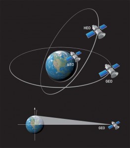
HEO: High-elliptical satellites in elongated orbits at great altitude crossing the poles.
LEO: Satellites in low Earth orbit above the poles at altitudes of 200–2000 kilometres.
GEO: Satellites in geo-stationary orbit above the equator.
SATELLITE PROBLEMS
Most satellites orbit around the latitude of the equator. The signals from these satellites become increasingly attenuated the further north one goes, because the angle between the receiver systems and the satellite sending the signal becomes too small. LEO systems orbit only 200-2000 kilometres above the Earth’s surface, but these systems have proved to be unstable. The solution may be high-elliptical satellites, which travel in elongated orbits at great altitude across the poles.
Ill: Knut Gangåssæter
Sensors on the seabed
Research scientists envisage various types of systems for monitoring ice – from measuring equipment on the ice that would transmit its position at regular intervals, to the use of unmanned aircraft and sensors on the seabed that could measure ice thickness.
Odd Kristen Østern Pettersen at SINTEF ICT can tell us more about the last of these alternatives. His department has been allocated funds to develop a system for monitoring ice using sensors on the seabed, in collaboration with the Nortek company. Statoil and Kongsberg Maritime are also involved in the project.
“We are talking about wireless sensors that will be located on the seabed to detect ice migration and thickness. At present a single sensor is deployed, which stores data until it is retrieved, perhaps several months later. We intend to create a live system that covers a large area and that will be more relevant to shipping and to operations in the ice field. The system will consist of a number of wireless sensors distributed over a large area, communicating with a base station on the seabed that transmits data to an ice-breaker or a petroleum platform. The plan is to deploy this kind of system in critical areas or in connection with critical operations,” says Pettersen.
Monitoring systems
Many institutions currently collect data about conditions at sea. The Norwegian Marine Research Institute acquires data about fishery resources, the Meteorological Institute deals with weather and oceanographic conditions, and the Coastal Administration studies shipping movements. The problem is that each institution focuses on its own areas of interest so that the data are only to a limited extent made available to other parties. This makes it difficult to create an integrated picture of the situation.
The Norwegian Coastal Administration is managing the development of a system that will correct this problem. In May, a pilot project began on an integrated monitoring and information system for the marine and coastal areas in northern latitudes, known as BarentsWatch. To make it work, all participating partners have to provide data to enable the study of weather conditions, polar fronts, shipping, ice conditions and vulnerable areas. Services will then be developed that combine the various data to provide new and important information about conditions at sea.
BarentsWatch will be developed in several phases. The first phase involves the establishment of an open information portal for the coastal and marine areas. In parallel with the gradual development of services in the open system, work is in progress to develop a closed, operational system that will provide a common, improved picture of the situation to government authorities with maritime responsibilities.
Marine charts and shoals
When icebergs move around in shallow waters, not only does the risk of collision increase, they may also change the topography of the seabed, with the result that navigation conditions are often different from those shown on marine charts. Norvald Kjerstad, a senior lecturer at Ålesund University College and a professor specializing in Arctic navigation at the University of Tromsø, has a passionate interest in marine charts. He has sailed aboard Russian icebreakers and travelled through the Northeast Passage several times. His experiences have led him to believe that the Barents Sea is a dangerous marine area, due to inadequate charts, frequent shoals and the prevalence of drift ice in large parts of the Norwegian zone. The same applies to areas around Greenland and Arctic Canada. The waters offshore Siberia are also characterized by extensive shallows in the delta areas where several major Russian rivers enter the ocean.
“There is a pressing need to generate new marine charts for the northern regions. The prevalence of shallow marine areas represents a risk. However, making marine charts is expensive and time-consuming. First of all, one has to be in the area while it is ice-free. Then one must systematically survey the area using multibeam echo sounder equipment, rather like ploughing a field. In this connection it is important to consider cost in relation to usefulness, based on how many ships travel in the area,” Kjerstad says.
200 metres from land
In December 2011, the Kolskaja platform was being towed towards the coast from the Kamchatka Peninsula in northern Russia. The rig workers had not been picked up by ships, but stood on deck while the towing was in progress. Two hundred metres from land, the platform capsized. Valves had been disabled by ice and waves, and the platform began to take on water. The crew waited to be evacuated by helicopter, but the platform sank before they were able to get aboard the lifeboats. The wind in the area was strong and the temperature was minus 17°C.
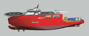
SHIPS FOR ARCTIC OPERATIONS
Ships intending to sail in the Arctic must be designed for Arctic conditions. Scientists have tested the drag, propulsion and seagoing properties of this 120-metre-long ship in the towing tank and marine basin at Marintek. The ship is specially designed for work at the Olga field, east of Svalbard, and as well as having good operational characteristics in open seas, it can navigate and operate in ice-covered waters.
Ill: STX OSV
Two of the platform’s four lifeboats were found with nobody aboard and rescue work was extremely difficult because of the weather. When aircraft and helicopters came ashore at around 7 p.m. local time, rescue personnel had spent more than six hours in the ice-cold water, according to the regional contingency organization. All the platform personnel wore lifejackets and survival suits, and those who were recovered from the water were in comparatively good condition, but while 80 survived, 14 perished.
The Norwegian Snøhvit field, in comparison, is located 140 kilometres from the coast, and the distance from the Kola Peninsula to the Russian Shtokman field is 600 kilometres.
Clothing
Hilde Færevik, a SINTEF health researcher, says it is impossible for people to imagine what it is like working in areas with the most severe climates, where temperatures plummet to as much as 60 degrees below zero.
“Because technical equipment needs constant maintenance at such extreme temperatures, personnel have no choice but to work outdoors from time to time. The Goliat platform, which is currently under construction, has a lot of open areas. This means that workers are exposed to risk, and in turn expose others to risk by making mistakes. Working on the Goliat field is one thing, but when Norwegian personnel begin to work closer to Russian waters, they will experience even more severe weather and more ice,” she says.
Færevik points out what is already well known: When the temperature falls, the body reacts by reducing the blood supply to the extremities, with the result that hands and feet get cold. How cold can you get before it affects your work performance? How long can you work outdoors before you are forced inside for safety reasons? These are questions research scientists are pursuing. They know that work performance suffers at temperatures as “warm” as plus 5 degrees, and that advanced protection is needed when personnel have to work outdoors in Arctic winds, storms and low temperatures.
Clothing that stores heat
“We envisage clothing made of functional materials that can, for example, store surplus heat from the body, which in turn can be retrieved from the fabric when the ambient temperature drops,” Færevik says. “We are also working on developing clothes with integrated sensors that can measure the temperature of the skin near the wrists. This can give a better indication than existing systems do of when personnel must stop work and go indoors to warm up. If things should go wrong and somebody falls overboard, the survival time is of course short.
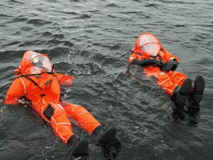
STANDBY TIME = TWO HOURS
In an emergency situation the standby time is set at two hours. Survival suits must therefore be adequate to withstand the extreme conditions in the Barents Sea. Here a Helly Hansen SeaAir helicopter transport suit is being tested in the field as part of a project SINTEF is conducting for the oil company Eni.
Photo: SINTEF
In an emergency situation the standby time is set at two hours. Survival suits must therefore be good enough to withstand the extreme conditions in the Barents Sea. This is something that has been a focus of the oil company Eni Norge. Three factors are particularly important: “The suits must prevent drowning and hypothermia, and they must be readily visible to rescue personnel,” says Færevik.
Færevik is talking about a situation that for most people is difficult to imagine: a rescue operation in rough sea where chaos and dark-ness prevail, with noise, shouting, howling wind and people floundering in the waves. “If there is to be any hope of saving anybody, they must be as visible as possible. We are working on improvements throughout, including the use of buddy lines and a visor which can provide better visibility,” she says.
Not always prepared
“Saving lives. Saving the environment. Saving material assets. These are the priorities,” says Professor Tor Einar Berg at NTNU. One of his principal areas of interest is safety and rescue in Arctic regions — and he is not satisfied with what he sees.
“There is a lack of maritime personnel with experience in Arctic waters, and there is a challenge in using foreign crews who belong in tropical countries and have only a poor understanding of critical conditions in the northern latitudes. In the Barents Sea, the air and water temperatures are low, even in the summer, and suitable work clothes are important. Such things are often lacking aboard ships that are on an occasional voyage in the summer,” he says.
Quick response is essential in the event of an accident, Berg explains. It is therefore important to know if there are other ships in the vicinity. “Today, larger ships are equipped with AIS (Automatic Identification System) technology, in compliance with IMO requirements. This is a type of black box which monitors ‘who, where and what’, and can indicate if there are other ships nearby. But because the AIS requirement only applies to ships over a certain size, we cannot rely on this system,” he says. Moreover, land-based AIS has a range of only 25-30 nautical miles (45-55 kilometres) from land. Kongsberg Seatex is currently working to improve this range.
Berg would like safety levels in the Arctic to be closer to the safety levels found in the offshore industry in general. “This level is often used as a reference for adequate contingency. Even so, accidents do happen, but in such cases the distance to land is relatively short. This will not be the case when the Barents Sea becomes an industrial arena: Distance and the weather will be the principal challenges for any industry establishing itself at these latitudes,” Berg says.
He strongly recommends investment in the training and education of personnel who will work in Arctic regions, as well as the creation of operational limits for critical marine operations, specific to individual vessels. “It’s no use having the world’s best ship if the operational planning ashore and the crew on board are not able to make use of that ship’s qualities. We need improved expertise and must avoid the propagation of faults and errors. We must therefore simulate all critical operations that are to be implemented in Arctic waters,” he adds. Norway is home to a number of simulators that can be used to educate and train marine personnel.
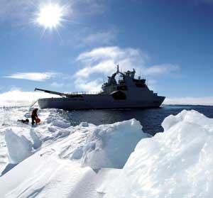
HAZARDOUS WATERS
The Norwegian Polar Institute is carrying out a survey of the water masses flowing into and out of the Arctic Ocean through the Fram Strait between Greenland and Svalbard. This is considered an ”artery” of the Arctic Ocean and is an important factor in understanding climate variations.
Photo: Norvald Kjerstad
Special vessels – one solution
Tor Einar Berg points out another key to success: cooperation with countries like Russia, Iceland and Greenland. He also recommends that ships intended for the Arctic be designed for Arctic conditions. “We have ships that have been designed and built to travel through ice, but they often have seagoing qualities that are inferior to those of vessels designed for open seas,” he says.
“Future designs must be capable of handling rapid changes of weather, unusual wave phenomena, strong winds, icing and ice migration. At the same time, emphasis must be placed on the development of rescue equipment that can function both in open and frozen waters.”
In Berg’s opinion, shipping should follow fixed corridors that are monitored and surveyed. The Danes, for example, have created a “safe corridor” off of Greenland. Similarly, Berg believes that zones should be established where it is safe to anchor in the event of incidents. Communications systems must also be accessible in these areas.
Improve safety levels
It is not just technology connected with monitoring that shows safety deficiencies. According to Berg, another problem is that existing survival suits are not good enough for use in areas like the Goliat field.
“The Barents Sea is considerably more severe than the Norwegian Sea as regards both low temperatures and wind. Here it is cold in the summer, too,” he points out. “A major problem is casual workers without experience or equipment suitable for working here. The Norwegian Coastal Administration, for example, has occasionally had to equip ship crews with thermal clothing, whereas oil companies that have established operations in the area are duty-bound to arrange for their own contingency systems. They will also develop their own contingency apparatus for year-round operations, since the authorities will not take responsibility for this.”
“Ultimately, functioning communications systems are a key to success in a rescue operation,” Berg says, but it won’t be cheap. “The cost of establishing a satellite-based broadband communications system in the area will probably be between five and six billion Norwegian kroner.”
By Christina Benjaminsen and Åse Dragland
