The ice in Antarctica has melted before
The ice sheet in Queen Maud Land in East Antarctica is not stable. Large amounts of ice have melted in the past, most recently as 5,000 years ago.
Sixty per cent of the world’s fresh water is bound up in Antarctic ice sheets. Thirty million cubic kilometres of ice is perhaps a difficult number to grasp. But if absolutely all Antarctica’s ice melted, the seas would rise by 58 metres on average.
“The ice sheet in East Antarctica stores enormous amounts of water. This means that this is the biggest possible source of future sea level rise – up to 53 meters if all of the East Antarctic ice melts – and is seen as the largest source of uncertainties in the future sea level adaptation planning,” says Irina Rogozhina, an associate professor at the Department of Geography at NTNU.
Most melting/ice loss in Antarctica happens through ocean-driven melting of ice shelves and ice calving. This, in turn, leads to an acceleration of ice streams on land and a greater discharge of ice into the ocean, where it gets lost to melting/calving, she said.
This was also likely the cause of larger ice loss during warmer periods of the past. In Greenland, these two processes contribute to about 65% of all ice loss.
But not all the ice needs to melt before it can have major consequences.
Researchers from NTNU were among a group of scientists who examined the ice in Queen Maud Land in East Antarctica. The results show that this ice sheet sector has varied a lot over time. This information is important as researchers try to learn more about the planet’s climate and how it is changing.
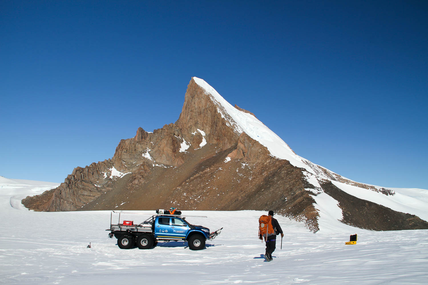
The American researcher Nat Lifton in front of Cottontop Mountain in Heimefrontfjella. He’s looking for rocks that can be collected and analysed for cosmogenic isotopes. The six-wheeled pickup truck is used to transport researchers from the Antarctic research station where they’re staying to their different field sites. Photo: Carl Lundberg
Rogozhina’s group studied the ice sheet in East Antarctica and a meltdown that took place a few thousand years ago. The results have been published in the Nature journal Communications Earth & Environment.
- You might also like: What kind of sea ice is that? Ask Knut!
The ice in the east lies on land
The ice sheet in Antarctica is not evenly distributed or uniform. In the west, large parts of the ice sheet lie under sea level, down to a depth of 2,500 metres. This makes it very vulnerable to ocean warming. In contrast, much of the ice sheet in the east sits directly on land, above sea level, meaning it is less sensitive to the ocean’s influence.
This ice sheet sector in East Antarctica was thinner in the past than it is now, and not particularly long ago either. In fact, it was thinner following the end of the last ice age, when massive ice sheets previously covered North America, northern Europe and southern South America. When these ice sheets melted, they raised the sea level by more than 100 metres.
“From the evidence we presented in our study, we concluded that the East Antarctic ice sheet in Queen Maud Land also melted rapidly along its margins between 9,000 to 5,000 years ago, in a period we call the mid-Holocene. At this time, many parts of the world experienced warmer-than-present summers,” Rogozhina said.
“Although this kind of response by the East Antarctic ice sheet to the warmth during the Holocene is not completely unexpected, it is still difficult and worrisome to believe that the sluggish East Antarctic ice sheet can change so rapidly,” she said.
It’s difficult to find a simple, easy explanation for this behaviour, or to determine the exact timing when the melting took place, not least because the conditions in this part of the world are rather inhospitable at times.
But the researchers found a way to unravel this mystery.
- You might also like: When a hole in the ice is a big problem
Cosmic radiation changes rocks
The research group examined rocks from various nunataks in Queen Maud Land for exposure to cosmic radiation.
“Nunataks are mountains that stick up through the ice. We have visited nunataks and taken samples,” says Ola Fredin, a professor at the Department of Geosciences and Petroleum.
The researchers examine different isotopes, or variants, of elements such as chlorine, aluminium, beryllium and neon in rocks from the nunataks. With the help of cosmogenic isotopes, they can figure out how high the ice was over geological time in Queen Maud Land. Fredin compares this to using a dipstick to measure the level of engine oil in your car.
In this way, the researchers can say something about how long the rocks have been exposed to cosmic radiation. They can then also say something about how long it has been since the rocks have been under a protective layer of ice and thus have not absorbed any cosmic radiation.
For this, they use data from different areas and run a variety of computer simulations.
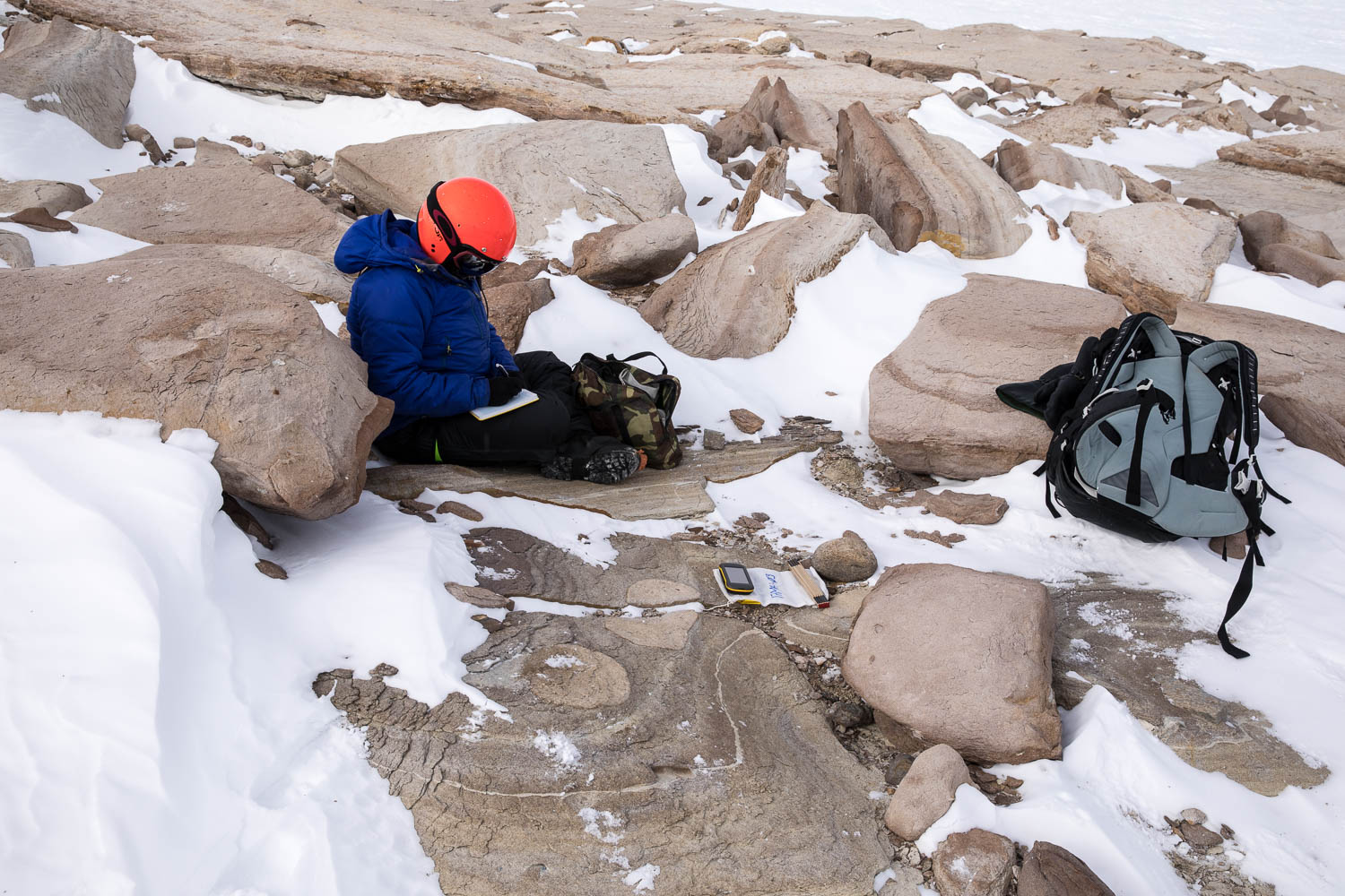
Doctoral student Jenny Newall takes notes high up in Heimefrontfjella. Here they had collected a loose rock, but it turned out to have been brought there by the ice. It was so cold and windy that they kept their helmets on to keep warm. Photo: Ola Fredin, NTNU
Rising seas and warmer water broke up the ice
The researchers also believe that they are on track to find a reason why the ice sheet sector in East Antarctica thinned so much immediately after the end of the last ice age.
“We believe that the ice sheet became less stable due to higher, regional sea levels and warmer water rising from the ocean depths in the polar regions, penetrating under the ice margins and melting them from below. This leads to the break-up of large icebergs and accelerates the movement of ice from the land to the ocean, which in turn thins the inland section of the ice sheet. The process is similar to when a house on a hill slope loses its supporting foundation and starts sliding downhill,” Rogozhina said.
In short, the less stable, rapidly flowing parts of the ice sheet in East Antarctica, which are called ice shelves and float on the ocean, were broken up more easily, which in turn led to the ice sheet becoming much thinner within a relatively short time, geologically speaking, or a few hundreds to thousands of years.
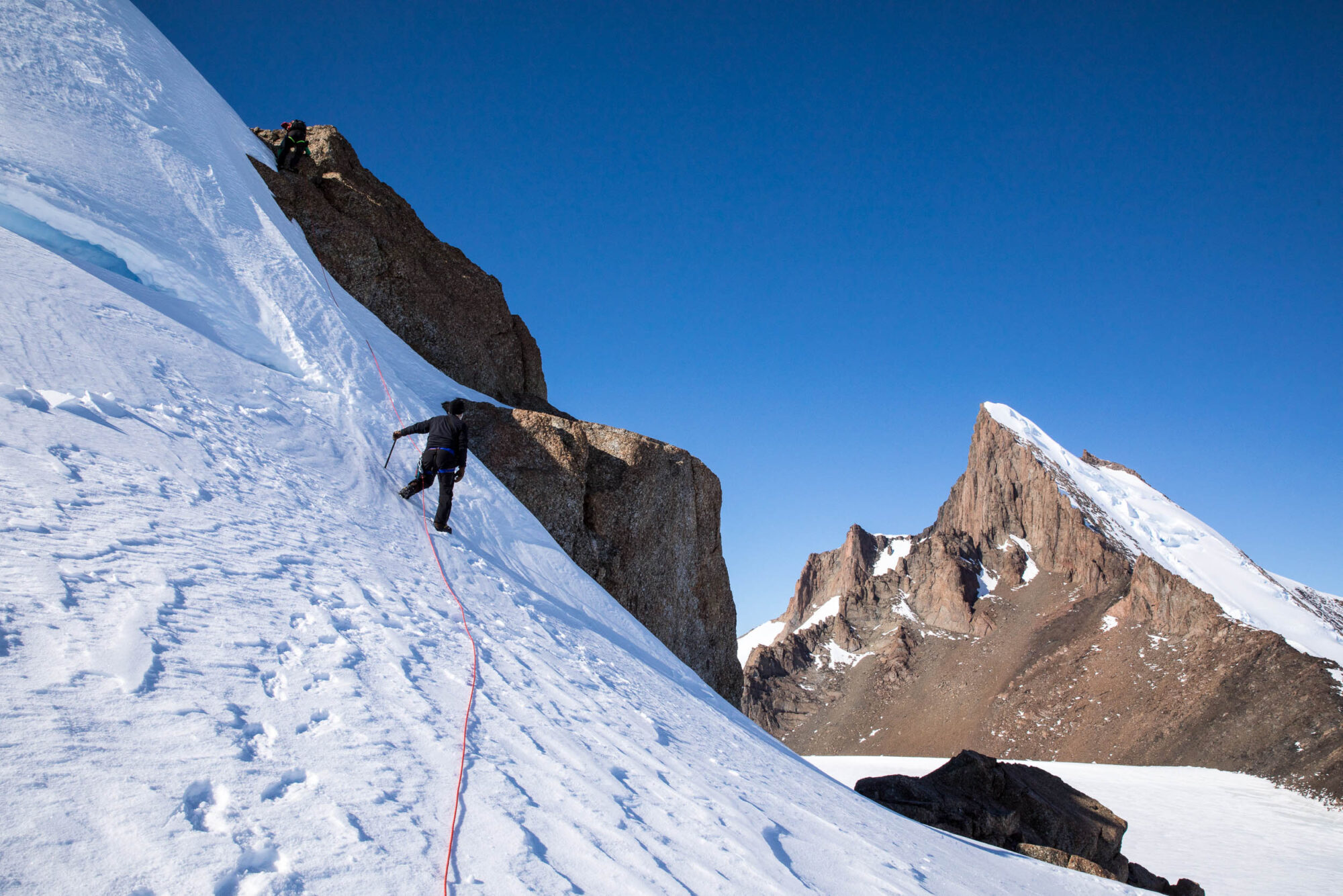
Researcher Nat Lifton (closest) and mountain guide Carl Lundberg (higher up) climb a small nunatak to look for suitable rock samples. Photo: Ola Fredin, NTNU
Thick ice is the most common along the coast
Cosmic radiation can also help researchers figure out how common it is for ice to cover an area. The researchers have also investigated this.
The results show that it is most common for the ice in Queen Maud Land to be thick along the coast. But not further into the continent, where mountain peaks protrude through the ice and the land can be several thousand metres high.
“We found that the land masses along the coast of Queen Maud Land have been covered by ice between 75 and 97 per cent of the time during the last one million years,” Fredin said.
He was part of another study, which has also had its results published in Nature Communications Earth & Environment. This group examined rocks from several different areas in Queen Maud Land, and found great variations.
“In contrast to areas along the coast, which have been ice-covered most of the time, we find that mountain summits further into the continent have been ice-covered as little as 20 per cent of the time,” Fredin said.
The ice sheet thickness and movement speed therefore vary a great deal over longer periods, and the mountain range further into the continent seems to be an important division between the dynamic coast and the ice sheet further towards the South Pole, which varies much less in thickness.
Watch a video that summarizes the article:
References:
Suganuma, Y., Kaneda, H., Mas e Braga, M. et al. Regional sea-level highstand triggered Holocene ice sheet thinning across coastal Dronning Maud Land, East Antarctica. Commun Earth Environ 3, 273 (2022). https://doi.org/10.1038/s43247-022-00599-z
Andersen, J.L., Newall, J.C., Fredin, O. et al. A topographic hinge-zone divides coastal and inland ice dynamic regimes in East Antarctica. Commun Earth Environ 4, 9 (2023). https://doi.org/10.1038/s43247-022-00673-6