Making regular GPS ultra-precise
Self-driving cars need to know exactly where on the road they are located at all times. A new invention could revolutionize the development of driverless vehicles – and give us more accurate GPS on our mobile phones and fitness watches too.
We mostly take it for granted that the position shown by our GPS is correct.
But if we are in a new city and use the map app on our phone to find our way back to the hotel, it can often look like we are jumping around from one point to another – even though we are actually walking perfectly normally on the same pavement the whole time.
“Cities are brutal for satellite navigation,” explained Ardeshir Mohamadi.
He is a doctoral student at NTNU and is working on how to make affordable GPS receivers (like the one in your mobile phone or your fitness watch) much more accurate without having to use costly additional services.
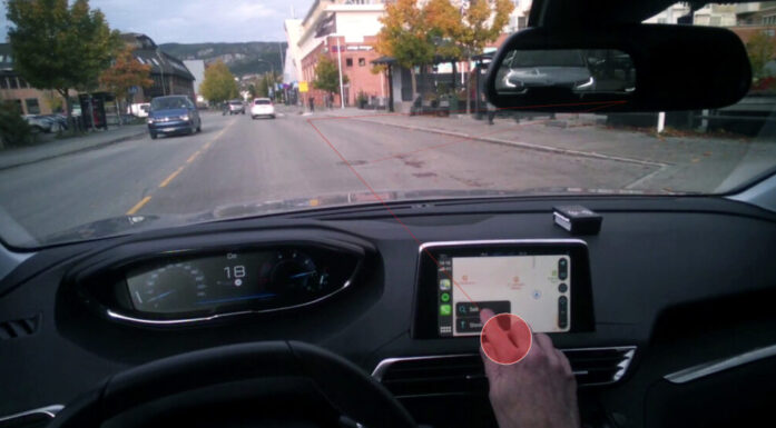
Having an accurate GPS position is especially important for cars that are designed to operate without a driver – so-called autonomous or self-driving vehicles.
FACTS: GPS – or rather GNSS
GNSS is a collective term for satellite-based systems for navigation and positioning with global coverage.
There are four established systems: the American GPS, the Russian GLONASS, the Chinese BeiDou, and the European Galileo.
Urban canyons
Mohamadi and his colleagues at NTNU have now developed a new system to help autonomous vehicles navigate safely within cities.

Ardeshir Mohamadi researches how affordable GPS receivers (like the ones we have in mobile phones or sports watches) can be made much more accurate without the need for expensive additional services. Photo: Omar Alexander Lein
“In cities, glass and concrete make satellite signals bounce back and forth. Tall buildings block the view, and what works perfectly on an open motorway is not so good when you enter a built-up area,” said Mohamadi.
The problem is that signals are reflected between buildings and take longer to reach the receiver. As a result, the calculation of the distance to the satellites is incorrect and the position becomes inaccurate.
These types of difficult city environments are often called ‘urban canyons’. It is as if you are at the bottom of a deep ravine. The GPS signals that reach you, or the self-driving vehicle, may have been reflected many times on their way down into the ravine.
“For autonomous vehicles, this makes the difference between confident, safe behaviour and hesitant, unreliable driving. That is why we developed SmartNav, a type of positioning technology designed for ‘urban canyons’,” explained Mohamadi.
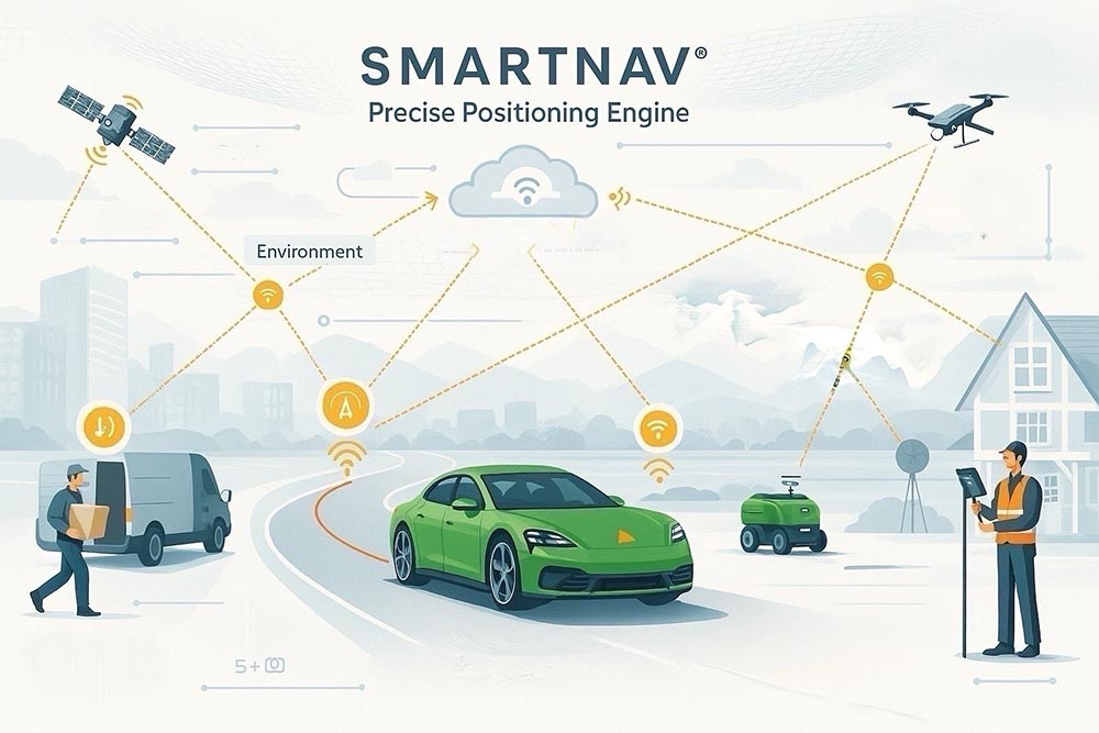
Researchers at NTNU have developed SmartNav, a positioning technology that provides highly precise GPS in urban areas where regular systems often fail. With advanced algorithms, SmartNav can make affordable receivers almost as accurate as expensive instruments.
Almost down to the centimetre
Not only are the satellite signals disrupted down between the tall buildings, but the signals that are correct do not have sufficient precision.
In order to solve this problem, the researchers have combined several different technologies to correct the signal. The result is a computer program that can be integrated into the navigation system of autonomous vehicles.
To achieve this, they received help from a new Google service, but before we go any further, it might be helpful to know how GPS works:
GPS – the Global Positioning System – comprises many small satellites orbiting the Earth. The satellites send out signals using radio waves, which are received by the GPS receiver. When the receiver receives these signals from at least four satellites, it is able to calculate its position.
The signal consists of a message with a code indicating the satellite’s position and the exact time the signal was transmitted – like a text message from the satellite.
- You might also like: Tips for if you get lost
Replacing the code with the wave
It is this code that often becomes incorrect when the signal bounces around between buildings in a city. The first solution the NTNU researchers studied was therefore to drop the code altogether. Instead, information about the radio wave can be used.
Is the wave travelling upwards or downwards when it reaches the receiver? This is called the carrier phase of the wave.
“Using only the carrier phase can provide very high accuracy, but it takes time, which is not very practical when the receiver is moving,” said Mohamadi.
The problem is that you have to stay still until the calculation is good enough – not just a microsecond, but for several minutes.
FACTS: Phase-only positioning (carrier-phase positioning)
Satellites transmit signals consisting of both a code and a carrier wave.
The code signal is normally used to calculate the distance to the satellite. In cities, the code is often disturbed by reflections from buildings (multipath), which creates large errors.
The carrier wave is a much more stable and precise part of the signal. It oscillates in a steady pattern (0–360°).
Phase-Only Positioning works by ignoring the code and using only the carrier wave to calculate position.
When the receiver knows which phase of the wave it is receiving, it can determine the distance to the satellite with very high accuracy.
However, one must figure out how many whole wavelengths have passed. This can be solved with advanced signal processing and the use of statistical methods.
However, there are other ways to improve a GPS signal. The user can use a service that corrects the signal using base stations called RTK (Real Time Kinetics).
RTK works fine as long as the user is in the vicinity of one of these stations. This solution, however, is expensive and intended for professional users.
An alternative approach is PPP-RTK (Precise Point Positioning – Real-Time Kinematic), which combines precise corrections with satellite signals. The European Galileo system now supports this by broadcasting its corrections free of charge.
But there is even more help available.
Google and the wrong-side-of-the-street problem
While the researchers in Trondheim were working on finding better solutions, Google launched a new service for its Android customers.
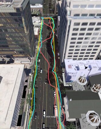
Google is now using its worldwide 3D map data to correct GPS signals in cities. The yellow line shows where the user is actually walking, while the red line is what a regular, uncorrected GPS shows. The blue line shows the route where the position is corrected with the help of the 3D maps. Source: Android Developers blog
Imagine you are planning a holiday to, say, London. You open Google Maps on your tablet. You then enter the address of your hotel and you can immediately zoom in on the street environment, study the hotel’s façade and the height of the surrounding buildings.
Google now has these types of 3D models of buildings in almost 4000 cities around the world. The company is using these models to predict how satellite signals will be reflected between the buildings. This is how they will solve the problem of it appearing as if you are walking on the wrong side of the road when using the map app, for example when trying to find your way back to your hotel.
“They combine data from sensors, Wi-Fi, mobile networks and 3D building models to produce smooth position estimates that can withstand errors caused by reflections,” explained Mohamadi.
- You might also like: When your house spreads gossip about you
Precision you can rely on
The researchers were now able to combine all these different correction systems with algorithms they had developed themselves. When they tested it in the streets of Trondheim, they achieved an accuracy that was better than ten centimetres 90 per cent of the time.
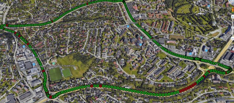
Result of a test drive with a driverless car in Trondheim, where NTNU researchers used their PPP-RTK–assisted solution. The green dots show position measurements with an accuracy better than ten centimeters. Illustration: Ardeshir Mohamadi.
According to the researchers, this provides precision that can be relied upon in cities.
The use of PPP-RTK will also make the technology accessible to the general public because it is a relatively affordable service.
“PPP-RTK reduces the need for dense networks of local base stations and expensive subscriptions, enabling cheap, large-scale implementation on mass-market receivers,” Mohamadi said.
FACTS: How are GPS signals corrected?
It’s not only reflections between buildings that can cause errors in GPS positions. Signal errors can occur at the satellites, in the atmosphere on the way down, and at the receiver. There are several ways to correct such errors.
RTK (Real-Time Kinematic)
RTK positioning is a method that uses GPS or other satellite-based navigation systems to determine precise positions in real time.
RTK positioning is a highly accurate method used in a wide range of applications, including surveying, construction, agriculture, and land management.
RTK requires two units: a base station and a mobile unit. The base station is located at a fixed position and collects satellite data. It then sends this data to the mobile unit, which uses it together with its GPS receiver to determine its precise position in real time.
PPP (Precise Point Positioning)
A method that allows a single receiver to achieve very high accuracy—down to decimeter or centimeter level.
Unlike RTK, PPP does not require a nearby base station. PPP uses global correction data for the satellites. This data is calculated from a network of global reference stations. With these corrections, the receiver can calculate a very accurate position—regardless of where in the world it is. However, PPP often requires a long startup time (convergence)—up to 20–30 minutes before centimeter accuracy is achieved.
PPP-RTK
Combines PPP’s global coverage with RTK’s fast convergence and high accuracy.
PPP-RTK uses both global corrections (PPP) and regional real-time data from reference stations.
Reference:
Ardeshir Mohamadi, Hossein Nahavandchi, Amir Khodabandeh: Phase-Only positioning in urban environments: assessing its potential for mass-market GNSS receivers Journal of Spatial Science, Published 25 July, 2025 https://doi.org/10.1080/14498596.2025.2536567
Coming soon: FLP-Aided GNSS RTK Positioning: A Means of Supporting Smartphone High-Precision Positioning in Dynamic Urban Environments Journal of the Institute of Navigation