Next chapter in Norway’s history is to conquer the oceans
Given that 70 percent of the Earth’s surface consists of water, the oceans will be the new arenas for more economic development in the future. NTNU is exploring the ocean depths using new technologies.
“The next chapter in Norwegian history will be about conquering the oceans,” said Jonas Gahr Støre at the 2016 Lerchendal Conference, an annual “by invitation only” gathering of business leaders from Norway’s largest and most important companies as well as representatives from politics and academia. Støre told the gathering about the great opportunities that lie in the oceans and about how Norway should begin to use and manage those opportunities.
Here’s how to extend Norway’s golden age
Ingrid Schjølberg is the director of NTNU Oceans, one of the university’s four Strategic Research Areas. “Norway has several competitive advantages when it comes to the ocean,” she said. “This is a huge unexplored field, and we’re working to build new knowledge, such as understanding the biochemical and geological processes in the seabed.”
“We need new technology to do things like map the ocean depths. And the development of underwater robotics and drone technology is exploding,” she said.
Pioneering deepwater dives
One ongoing research project that NTNU is involved in is the Kon-Tiki2 expedition in the Pacific Ocean. The expedition is currently on its way from Easter Island to South America.
- You might also like: Kon-Tiki2 expedition in Heyerdahl’s wake
On board the expedition’s two primitive balsa rafts is brand new technology for gathering research data from the wide stretches of ocean that the rafts are crossing. Pedro De La Torre from NTNU oversees the technology, and on 29 January, the expedition completed a pioneering deepwater dive.
Climate data down to 2,500 meters
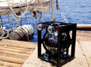
This deepwater camera, equipped with sensors, was dropped to a depth of 2450 metres off the coast of Easter Island. Photo: Kon-Tiki2
Both a deepwater camera and a CTD — an oceanography instrument that measures salinity, depth, temperature, oxygen and chlorophyll — were lowered to 2,450 metres.
Sunlight cannot penetrate more than 200 metres below the ocean’s surface, and so this camera was designed with a separate light source to be able to film in the dark ocean depths. Deepbots AS in Norway developed the camera.
Usually large cranes and a well-equipped research vessel are used to operate this kind of advanced equipment, requiring large financial investments. One of the advantages of the Kon-Tiki2 measurements is that this is low-cost research. But operations can have their challenges.
De La Torre, an oceanographer who also heads up the research on the Kon-Tiki2 expedition, explains why. “Lowering the instruments down went smoothly. But raising them up again demanded the all-out effort of everyone on board. We struggled with knots in the Kevlar rope, a camera that weighs 10 kg, one CTD weighing 3 kg and 10 kg of rocks used as a sinker. When you add the enormous resistance of the water, the task is quite inhuman. By rotating the seven crew members, we managed to raise the instruments.”
All scientific data from the expedition will be analysed through a partnership between the Norwegian Institute for Water Research (NIVA) and NTNU at the end of the expedition.
Blue mining
Another ongoing research field is the NTNU Deep Sea Mining pilot project, which aims to map mineral resources found on the seabed. Submarine volcanoes (black smokers) bring minerals and metals up to the seabed from the Earth’s magma. Nickel, copper, zinc, cobalt, silver and gold are among the minerals to be found.
The demand for minerals and non-ferrous metals used in smart phones, laptops, LED lights and electric motors is constantly increasing. And mines on land are about to run out.
Minerals on the ocean floor currently constitute a huge unexplored realm.
“Extraction of these minerals will require that we adopt the most advanced expertise we have in geology, underwater technology and marine operations — along with research expertise in ethics and sustainability,” says Schjølberg.
- You might also like: Mining ocean treasures
Bilder fra dypet
Ecotone, a spin-off company from NTNU that develops new technologies to explore the ocean depths, has also developed an underwater camera called the Ecotone Scientific UHI (Underwater Hyperspectral Imager). It is the first UHI that is designed to go as deep as 6,000 metres, and was tested on a research expedition in the Pacific last fall.
The hyperspectral camera “was mounted on an ROV to attempt to detect nodules using optical spectral response. In the future, we hope this will be developed into a method to detect minerals in connection with exploration and extraction of marine mineral resources,” says Martin Ludvigsen at the Department of Marine Technology.
Complete light spectrum
PhD candidate Stein Melvær Nornes, as from the Department of Marine Technology, got to handle the UHI camera on the research vessel Sonne, which set out from Guayaquil in Ecuador. This camera is far heavier than what was tested on the Kon-Tiki 2 raft—35 kg—and therefore requires more equipment to lower and raise it. The camera was used to map the sea floor at a full 4200 metres depth.
“Being able to test new technology is always exciting. Hyperspectral imaging has been implemented successfully by planes and satellites, but the underwater use of this technology has only just begun,” says Nornes.
While conventional cameras — and our own eyes — operate with a colour range using only three colours (blue, red and green), this camera uses 100 different colour values. It allows pictures taken by the UHI camera to contain an enormous amount of information.
Now Nornes is working to analyse the images.
“Each pixel that’s imaged with a camera like this contains a full light spectrum of colour nuances. Now we’re researching how we can utilize all the information in the images. If we can rely on this kind of distance measurement as a method instead of having to get physical samples, it will simplify the mapping significantly,” he said.
“Some follow-up work with the image material still has to be done before the real data interpretation can begin. But we can already see that a computer can use these “optical fingerprints” for automatic classification,” Nornes adds.
First research expedition to the deep ocean
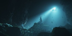
In August, NTNU will head into the depths around Jan Mayen Island to check out underwater volcanoes and adjacent mineral deposits. Illustration:NTNU
Submarine volcanoes occur where continental plates meet and form openings in the ocean floor. They can be found along the Mid-Atlantic ridge between Jan Mayen and Svalbard islands. NTNU has estimated that the Norwegian continental shelf may contain minerals and metals of great value.
This summer NTNU will be conducting the first research expedition to explore the seabed around Jan Mayen. The research vessel will carry some twenty scientists and equipment to operate an unmanned mini-submarine (ROV) and an automatically controlled mini-submarine (AUV). In addition, dynamic positioning will be important for the ship so that it remains stable in the harsh weather conditions in the area.
“With the cable-controlled ROV we’ll examine the seabed down to 1500 metres, and with the AUVs down to around 3000 metres,” expedition leader Ludvigsen told Maritime.no.
Bringing up several hundred kilos of minerals
NTNU Oceans
NTNU has identified four strategic research areas that will bring together the best minds for interdisciplinary research. The NTNU Oceans strategic area includes the following cutting-edge research areas:
- Green maritime transport
- Into the deep ocean
- Oil and gas from the north
- Sustainable seafood
- Clean energy from the sea
- Marine environment, society and sustainability
Impacts on the seabed ecosystem
The consequences that seabed mineral extraction will have on the ecosystem of the ocean depths are not yet clear. This aspect is therefore a very important part of the research. The NTNU Deep Sea Mining Project is collaborating with ethics scholars to address the ethical considerations of this potential new offshore industry.
